Local Terroir
Geology and Vineyard Soils
California is a geologist’s paradise – an open laboratory for observation of the majestic forces that formed, and continue to alter, the entire planet. When we study the broad diversity of the Golden State’s winegrowing regions, it helps to understand the earthly forces that created this bewildering array of landforms and vineyards. The following is a very simplified overview of those forces and how they affect the state’s wines.
California has been created by faulting, folding, subduction, accretion, volcanism, glaciation, sedimentation and more. The land surface has been bent, stretched, fractured, uplifted, collapsed, filled, eroded and submerged multiple times. It is the product of the most basic of tectonic forces laid out for all to see because, in geologic terms, much of it has happened very recently and quite rapidly.
So many of California’s winegrowing regions exist because of recent geologic processes. Mountain ranges rise and valleys subside. Gravity always rules and weathered rock fragments move from high places to lower ones, filling valleys with sediments from their surroundings. Rivers and streams – alluvial forces – are the primary drivers that move sediments from one place to another. Alluvial soils are a common reference in vineyard descriptions, but that is not very definitive. Depending on geologic history, slope, proximity to upland areas, rainfall and other factors, alluvial soils can be any combination of sand, gravel, silt, clay and others. While a specific vineyard site may have properties influenced by a particular stream in that spot, the fluvial influence is so variable that it is difficult to impose that set of characteristics on another alluvial area. Thus, even in a small confined area like the Napa Valley, soil types can, and do, vary widely.
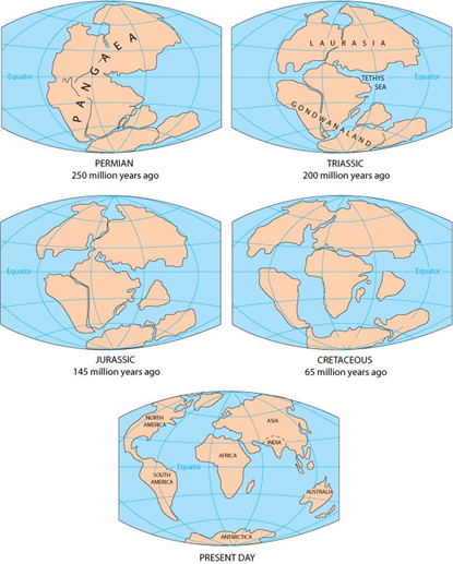
Movement of Tectonic Plates over the past 250 million years
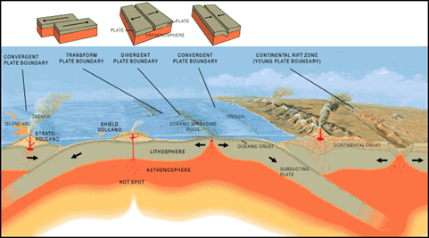
To understand the underpinnings of California’s geology and why our famous winegrowing regions exist, we must understand the concept of plate tectonics. The Earth’s crust is actually a thin layer of the planet, often compared to the shell of an egg. The crust is not solid, however, but composed of tectonic “plates” that can move around. There are about a dozen major plates and many subsets of these that can be referred to individually.
Throughout its four-and-a-half-billion-year existence, the Earth’s land mass has been in motion. It is thought that the heat generated by radioactive decay within the planet is sufficient to keep part of the interior molten. Basic physics shows that hot liquids rise and since the Earth is hotter near the core, upward convection currents occur. When these break through the Earth’s surface, they bring the molten rock with them, creating new crust – effectively adding on to the oceanic plates. This upwelling of new rock most often occurs along mid-ocean ridges and the newly formed crust spreads out in both directions from that center. The size of the planet is fixed, however, and new crust cannot be formed without something happening to reduce the old in commensurate volume. Thus, all tectonic plates are destined to conflict with others as they move.
The Dynamics of Plate Tectonics – When Plates Collide
When plates move toward each other, they collide in a boundary that is active or convergent and may result in subduction, where one plate passes under the other and reduces the size of the Earth’s crust. The collision of plates is the force that has forged the land we know as California. Around 250 million years ago, the supercontinent of Pangaea began to break up. The North American continent moved westward after the breakup and the west coast was in modern Nevada. Everything to the west was ocean. Ultimately, the moving plate collided with the Farallon Plate, an oceanic plate which was spreading eastward. Around 100 million years ago, as the denser rocks of the Farallon were subducted, or pushed under North America, they plunged deeper into the Earth’s mantle and were melted miles below the surface, forming an immense body of granite. Millions of years later, these rocks would become the Sierra Nevada range and the granite would form the base of the Sierra Foothills vineyard soils. As these granitic rocks weathered and washed down into the San Joaquin Valley, they formed the sandy loam soils of the Mokelumne River Valley near Lodi. The pressures involved in this plate collision also caused the interior of the North American continent to rise.
Some of the molten rock would rise through weak places in the crust, leading to the formation of volcanoes on the North American surface. Volcanic islands formed to the west, and what is now the Inland Valleys of California were a broad, shallow sea. The new mountain ranges to the east and west were eroding rapidly as well, filling the basin with thousands of feet of sediment – a combination of gravel, sand, silt, clay and volcanic ash. Too, as the plates collided, parts of the descending Farallon Plate, rocks now known as the Franciscan Formation, were scraped off and pasted onto the advancing North American plate, a process known as accretion. The Franciscan assemblage is thousands of feet thick and is an agglomeration of sandstones, shales, serpentinites, volcanic rocks, and even some limestone beds which outcrop in San Benito County in the Gabilan Mountains.
Around thirty-million years ago the movements were altered. The North American Plate overran the oceanic Farallon plate and the geometry changed. The new contact was with the north-moving Pacific Plate, so rather than the intense, head-on pressure of convergence, there was lateral pressure as the plates slid in opposite directions. This new conflict created the huge rift we know as the San Andreas fault zone that drives much of California’s seismic activity.
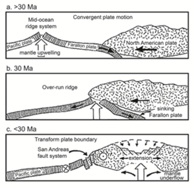
The Farallon Plate over-run by the North American Plate
Across North America, almost all mountain ranges trend in a north-south direction. One major exception is the Transverse Ranges of Southern California. As the Pacific Plate moved northward in relation to the North American Plate, it rotated the Transverse Ranges around 90° into the current east-west orientation. This change of direction has had a profound influence on winegrowing since cool marine air can easily be drawn into the transverse valleys. The vineyards of the Santa Maria Valley, Sta. Rita Hills, Santa Ynez Valley and more benefit greatly from this cooling influence.
The change in plate contact from directly convergent to side-by-side movement did not eliminate pressure. The plates exert enormous force as they grind against each other. Plus, plate motions would have slight changes in direction, changing the pressure pattern entirely. In some places, divergent forces stretched the Earth’s surface, causing valleys to sink and forming weak places in the crust that allowed volcanoes to rise. Mountains were still pushed upward. Seas intruded or abated as the land surface rose and fell. Erosion and deposition continued apace.
As the Pacific Plate dragged the western slice of California northward, it brought a sequence of eruptive volcanic phases with it. Between ten- and three-million years ago, a series of volcanic episodes occurred in Northern California. Known as the Sonoma Volcanics, it involved multiple eruptions, ash falls and basalt flows over several million years. The area that is now the Napa Valley was dotted with volcanic vents and peaks that erupted large amounts of ash. The Chalk Hill AVA in Sonoma County is named for its white, volcanic ash soil. Volcanic soils are far from uniform, however. Volcanic activity encompasses ash falls, ash flows, mudflows, lava flows and more. Eruptions can be explosive, with tons of debris hurled into the air, or milder with lava flowing across the land surface. These raw, newly erupted sediments are incorporated into ongoing sedimentary processes, and the seas, lakes and rivers all absorb the volcanics and meld them into the sediment mix.
In Sonoma County, the coast was farther to the east than it is today. A thick wedge of sandy sediment was deposited along the shore. These sand beds became the Wilson Grove Formation, which is the base rock for the noted Goldridge soils of Sonoma County. Similarly, to the south of the Bay, the Salinas Valley of Monterey County was a shallow sea that filled with sediment from the rising Santa Lucia and Gabilan Mountains. This valley and the slopes above were destined to become the noted vineyard sites of Arroyo Seco, Chalone, and the Santa Lucia Highlands. Shallow seas had also encroached in Southern California. The relatively shallow marine environment allowed the Monterey Formation limestone beds to be deposited in what is now the west Paso Robles area.
The many diverse and recently formed valleys throughout California are often sculpted by alluvial fans. Alluvial fans are aptly named for their fan-like appearance on a map. They are formed when a stream emerges from an upland area into an adjoining valley. As streams descend from higher elevations at a steep gradient, they naturally flow rapidly. The strong current carves the surrounding landscape, eroding its banks and pulling the surrounding material down with it. These mountain watercourses can have considerable capacity to carry cobbles, gravel, silt, sand and clay, especially in times of flood and high flow.
As a stream or river emerges into a valley, the gradient diminishes markedly, the flow rate decreases and the carrying capacity drops substantially as well. Thus, the water loses much of its energy and can no longer carry the coarse-grained sediments along. Alluvial fans almost always consist of coarse-grained, poorly sorted deposits, since the energy loss of its transporting medium is profound and leads to rather random deposition patterns.
California offers fine examples of vineyards on alluvial fans. Vines in Rutherford and Oakville in Napa Valley are frequently on alluvial fans brought down from the Mayacamas Mountains. On the east side of the Napa Valley there are alluvial fan influences as well. The famed Three Palms Vineyard is located on an alluvial fan created by the outwash of Selby Creek where it spills out of Dutch Henry Canyon. The site is covered with volcanic stones washed down from the canyon. In Sonoma County, the Alexander Valley is noted for its well-drained vineyards on alluvial fan deposits. The Russian River Valley has many Pinot Noir sites that rest on the gravelly sediments of alluvial fans as well.
The land we call California has traversed the globe through billions of years. The roots of the land that so bountifully supports the grapevine are tied to its geologic history. The region has moved across many degrees of latitude and longitude, collided and bumped against other plates multiple times, endured and grown as mountain ranges rose up and eroded. It has harbored inland seas as waters advanced and then receded, and at times has been partly submerged beneath the ocean. There is no other place in the wine world as diverse and active as the Golden State.
Climate and Weather
California is a sweet spot for winegrapes. With a long growing season, vineyards thrive in many places because the climate is so amenable to proper ripening of the fruit. California wine country is noted for its Mediterranean climate. Similar to lands in Italy, southern France and elsewhere around the Mediterranean Basin, California vineyards receive most of their annual rainfall in the winter and early spring. The summer ripening season is generally warm and dry. The reason for this agricultural bounty lies in part with the atmospheric and ocean current influences on the California landscape.
One powerful influence is the presence of the Pacific High, an area of high atmospheric pressure located off the California coast. It moves northward in the summer and shunts storm systems away from the heart of wine country. In the winter, the Pacific High moves southward, and moisture-laden Pacific storms can then bring their rainfall to land. The rain can be substantial. The Napa River has had 22 significant flood events since records began in 1862, about once every seven years on average. The Russian River at Guerneville in Sonoma County has flooded 38 times in the last 80 years. Prolonged drought can also be a potential problem. California has experienced several five- to 10-year periods of drought in the historical record, and paleoclimate data indicates droughts of 100-200-year duration have occurred in the last one thousand years.
Just off the coast, the California Current flows south from British Columbia to Baja. This is a cold-water current, with temperatures sometimes 10° F (12.2° C) lower than the Pacific Ocean water to the west. When warmer, moist air is pushed by the prevailing west winds over the California Current, the temperature differential causes condensation and forms thick fog banks. As the sun warms the earth inland, the hot air rises, drawing the cold marine air and fog into the valleys. This daily cycle reduces the temperature and allows for slower ripening of the grapes. This beneficial cooling is an important factor for winegrowing regions all along the coast. From Mendocino to Napa to Monterey to Santa Barbara, the influence of marine air and fog moderate what might otherwise be too warm a climate for fine wine production.